Rikcha:Arunachal Pradesh locator map.svg

Qallariy willañiqi (SVG willañiqi, rimasqakama 2393 × 1956 iñuyuq, willañiqip chhikan kaynin: 263 kB)
| Kay willañiqiqa kay uranpi yapa willasqakunapas Wikimedia Commons sutiyuq chawpi midya hallch'amantam ch'aqtasqa. | Commons nisqapi ch'uyanchana p'anqaman |
| Título |
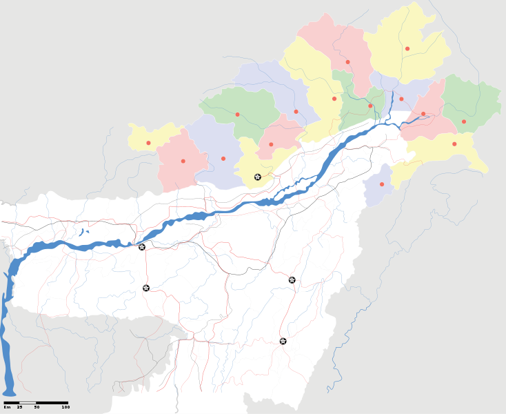
Arunachal Pradesh locator Map. Coordinates: top=29.49, bottom=23.74, left=89.61, right=97.52. |
||
| Descripción |
Map of w:Arunachal Pradesh with road and rail lines |
||
| P'unchaw | |||
| Pukyu |
Kikinpa rurasqan |
||
| Creador |
|
||
| Saqillay (Kay willañiqita musuqmanta llamk'achiy) |
Ñuqaqa, kay rurasqaypa iskaychay hayñiyuq kaqnin, kaywan rurasqayta uyaychachkanim kay qatiq saqillaywan: Kay willañiqiqa Creative Commons nisqap kay hinallataq rakinakuy 3.0 mana apasqa saqillayninwanmi saqillasqa.
|
||
| Geotemporal data | |||
| Fecha representada | 20 ñiqin pachakwata qhipaq kuskanpiwan 21 ñiqin pachakwatapas | ||
| Georeferencing | If inappropriate please set warp_status = skip to hide. | ||
| Archival data | |||
| Notas | Part of WikiProject India Maps | ||
derivative works
Derivative works of this file: India Arunachal Pradesh location map.svg
Willañiqip wiñay kawsaynin
P'unchaw/pacha nisqapi ñit'iy chaypacha willañiqi kachkasqata qhawanaykipaq.
| P'unchaw/Pacha | Uchuylla rikchacha | Chhikanyachikuqkuna | Ruraq | Willapuy | |
|---|---|---|---|---|---|
| kunan | 19:04 16 awr 2007 | | 2393 × 1956 (263 kB) | Planemad | {{WikiProject_India_Maps |Title=Arunachal Pradesh locator Map |Description=Map of w:Arunachal Pradesh with road and rail lines |Source= [http://www.iitg.ernet.in/rcilts/assam_political.jpg IIT Guwahati - Assam Political map], [http://arunachalgovernor |
Maypim willañiqita llamk'achinku
Kay rikchamanqa kay qatiq p'anqam t'inkimun:
Mayqin wikikunapi willañiqita llamk'achinku
Kay wakin wikikunam willañiqitaqa llamk'achinku:
- ast.wikipedia.org-pi kaykunapi llamk'achinku
- as.wikipedia.org-pi kaykunapi llamk'achinku
- awa.wikipedia.org-pi kaykunapi llamk'achinku
- ba.wikipedia.org-pi kaykunapi llamk'achinku
- ca.wikipedia.org-pi kaykunapi llamk'achinku
- ceb.wikipedia.org-pi kaykunapi llamk'achinku
- de.wikipedia.org-pi kaykunapi llamk'achinku
- dty.wikipedia.org-pi kaykunapi llamk'achinku
- dv.wikipedia.org-pi kaykunapi llamk'achinku
- en.wikipedia.org-pi kaykunapi llamk'achinku
- es.wikipedia.org-pi kaykunapi llamk'achinku
- fa.wikipedia.org-pi kaykunapi llamk'achinku
- fr.wikipedia.org-pi kaykunapi llamk'achinku
- hif.wikipedia.org-pi kaykunapi llamk'achinku
- hi.wikipedia.org-pi kaykunapi llamk'achinku
- hr.wikipedia.org-pi kaykunapi llamk'achinku
- id.wikipedia.org-pi kaykunapi llamk'achinku
- incubator.wikimedia.org-pi kaykunapi llamk'achinku
- ja.wikipedia.org-pi kaykunapi llamk'achinku
- ka.wikipedia.org-pi kaykunapi llamk'achinku
- kbd.wikipedia.org-pi kaykunapi llamk'achinku
- mai.wikipedia.org-pi kaykunapi llamk'achinku
- ml.wikipedia.org-pi kaykunapi llamk'achinku
- ms.wikipedia.org-pi kaykunapi llamk'achinku
- new.wikipedia.org-pi kaykunapi llamk'achinku
- nl.wikipedia.org-pi kaykunapi llamk'achinku
Qhaway mayqin wikikunapim willañiqita llamk'achinku.