Rikcha:Satellite image of Philippines in March 2002.jpg

Kay ñawpaq qhawariypa chhikan kaynin: 460 × 600 iñu. Huk huyakukuna: 184 × 240 iñu | 368 × 480 iñu | 589 × 768 iñu | 785 × 1024 iñu | 1570 × 2048 iñu | 4600 × 6000 iñu.
Qallariy willañiqi (4600 × 6000 iñu; willañiqip chhikan kaynin: 3,58 MB; MIME laya: image/jpeg)
| Kay willañiqiqa kay uranpi yapa willasqakunapas Wikimedia Commons sutiyuq chawpi midya hallch'amantam ch'aqtasqa. | Commons nisqapi ch'uyanchana p'anqaman |
Pisichay
| T'iktuna |
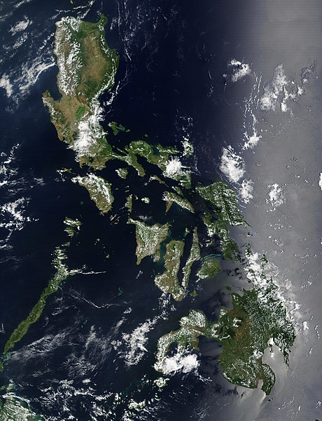
Satellite image of Philippines in March 2002. |
| P'unchaw | |
| Pukyu | http://visibleearth.nasa.gov/view_rec.php?id=2689 |
| Ruraq | NASA |
Saqillaspa
| Este archivo es de dominio público porque fue creado por la NASA. Las políticas sobre copyright de la NASA estipulan que «el material de la NASA no está protegido con copyright a menos que se indique lo contrario». (Políticas sobre copyright de la NASA o Políticas sobre la utilización de imágenes del Jet Propulsion Laboratory). | ||
 |
Advertencias:
|
Willañiqip wiñay kawsaynin
P'unchaw/pacha nisqapi ñit'iy chaypacha willañiqi kachkasqata qhawanaykipaq.
| P'unchaw/Pacha | Uchuylla rikchacha | Chhikanyachikuqkuna | Ruraq | Willapuy | |
|---|---|---|---|---|---|
| kunan | 11:32 21 dis 2004 | | 4600 × 6000 (3,58 MB) | Hautala | {{PD-USGov-NASA}} Satellite image of Philippines in March 2002. Taken from NASA's Visible Earth http://visibleearth.nasa.gov/cgi-bin/viewrecord?12847 . Description: Red dots (or outlines in the high-resolution imagery) indicate MODIS9 detection of thermal |
Maypim willañiqita llamk'achinku
Kay rikchamanqa kay qatiq p'anqam t'inkimun:
Mayqin wikikunapi willañiqita llamk'achinku
Kay wakin wikikunam willañiqitaqa llamk'achinku:
- af.wikipedia.org-pi kaykunapi llamk'achinku
- bg.wikipedia.org-pi kaykunapi llamk'achinku
- bn.wikipedia.org-pi kaykunapi llamk'achinku
- ca.wikipedia.org-pi kaykunapi llamk'achinku
- da.wikipedia.org-pi kaykunapi llamk'achinku
- de.wikipedia.org-pi kaykunapi llamk'achinku
- de.wikinews.org-pi kaykunapi llamk'achinku
- en.wikipedia.org-pi kaykunapi llamk'achinku
- Outline of the Philippines
- Deforestation by continent
- Deforestation in the Philippines
- Wikipedia:Featured picture candidates/Satellite image of the Philippines
- Wikipedia:Featured picture candidates/September-2012
- Wikipedia:Featured picture candidates/February-2014
- Wikipedia:Featured picture candidates/Philippines (Satellite)
- en.wikiversity.org-pi kaykunapi llamk'achinku
- en.wiktionary.org-pi kaykunapi llamk'achinku
- fi.wikipedia.org-pi kaykunapi llamk'achinku
- gl.wikipedia.org-pi kaykunapi llamk'achinku
- he.wikipedia.org-pi kaykunapi llamk'achinku
- תבנית:הידעת? 5 בנובמבר - סדרה 2
- פורטל:ארצות הברית/הידעת?/קטעי הידעת
- פורטל:ארצות הברית/הידעת?/50
- פורטל:יפן/הידעת?/קטעי הידעת
- תבנית:הידעת? 5 בנובמבר 2014
- ויקיפדיה:הידעת?/2014/נובמבר
- ויקיפדיה:הידעת?/2016/נובמבר
- תבנית:הידעת? 5 בנובמבר 2016
- ויקיפדיה:הידעת?/2018/נובמבר
- תבנית:הידעת? 18 בנובמבר 2018
- תבנית:הידעת? 1 בנובמבר 2019
- ויקיפדיה:הידעת?/2019/נובמבר
- ויקיפדיה:הידעת?/2021/נובמבר
- תבנית:הידעת? 7 בנובמבר 2021
- פורטל:יפן/הידעת?/23
- תבנית:הידעת? 5 בנובמבר 2023
- ויקיפדיה:הידעת?/2023/נובמבר
- ht.wikipedia.org-pi kaykunapi llamk'achinku
- incubator.wikimedia.org-pi kaykunapi llamk'achinku
- mdf.wikipedia.org-pi kaykunapi llamk'achinku
- nl.wikipedia.org-pi kaykunapi llamk'achinku
- nl.wiktionary.org-pi kaykunapi llamk'achinku
- no.wikipedia.org-pi kaykunapi llamk'achinku
- pap.wikipedia.org-pi kaykunapi llamk'achinku
- pl.wikinews.org-pi kaykunapi llamk'achinku
- sk.wikipedia.org-pi kaykunapi llamk'achinku
- sm.wikipedia.org-pi kaykunapi llamk'achinku
- sr.wikinews.org-pi kaykunapi llamk'achinku
- trv.wikipedia.org-pi kaykunapi llamk'achinku
Qhaway mayqin wikikunapim willañiqita llamk'achinku.