Rikcha:Karte Deutschland.png
Manam kanchu aswan huyakuyuq rikcha.
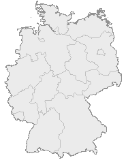
Karte_Deutschland.png (188 × 235 iñu; willañiqip chhikan kaynin: 2 kB; MIME laya: image/png)
| Kay willañiqiqa kay uranpi yapa willasqakunapas Wikimedia Commons sutiyuq chawpi midya hallch'amantam ch'aqtasqa. | Commons nisqapi ch'uyanchana p'anqaman |
| T'iktuna |
English: Map of Germany with the borders of the 16 federal states.
Deutsch: Karte von Deutschland mit den Grenzen der 16 Bundesländer. |
| P'unchaw | Mana riqsisqa p'unchaw |
| Pukyu | OpenGeoDB |
| Ruraq | NN/OpenGeoDB |
| Saqillay (Kay willañiqita musuqmanta llamk'achiy) |
GFDL |
This image was generated with OpenGeoDB. The information there is placed in the public domain, images generated from OpenGeoDB are derivative works without passing the threshold of creativity, they are therefore also public domain.
| Esta imagen no es elegible para estar sujeta a derecho de autor y por tanto está en el dominio público, porque consiste enteramente en información que es de propiedad común y carece de autoría original. |

|
File:Germany location map.svg es una versión vectorial de este archivo. Debería usarse esa versión en lugar de este archivo PNG, cuando sea mejor.
File:Karte Deutschland.png → File:Germany location map.svg
Para más información, lee Ayuda:SVG. |
 |
Willañiqip wiñay kawsaynin
P'unchaw/pacha nisqapi ñit'iy chaypacha willañiqi kachkasqata qhawanaykipaq.
| P'unchaw/Pacha | Uchuylla rikchacha | Chhikanyachikuqkuna | Ruraq | Willapuy | |
|---|---|---|---|---|---|
| kunan | 18:46 8 ini 2008 | | 188 × 235 (2 kB) | Evilboy | Reverted to version as of 20:35, 14 March 2007 |
| 20:35 14 mar 2007 |  | 188 × 235 (2 kB) | Tene~commonswiki | Optimised (0) | |
| 11:28 9 phi 2007 |  | 188 × 235 (2 kB) | TMg | Contrast slightly improved without loosing precision | |
| 19:04 31 ini 2007 |  | 188 × 235 (2 kB) | Leit | Auf eine alte Version zurückgesetzt | |
| 18:17 31 ini 2007 |  | 188 × 235 (8 kB) | Der Eberswalder | ||
| 12:29 31 ini 2007 |  | 188 × 235 (2 kB) | Rauenstein | Auf eine alte Version zurückgesetzt | |
| 11:04 31 ini 2007 |  | 188 × 235 (8 kB) | Der Eberswalder | now white color outside the borders | |
| 10:31 31 ini 2007 |  | 188 × 235 (2 kB) | Siebrand | Eerdere versie hersteld | |
| 06:31 31 ini 2007 |  | 188 × 235 (9 kB) | Der Eberswalder | better viewable | |
| 15:48 27 awu 2006 |  | 188 × 235 (2 kB) | TMg | Slightly error corrected version, based on Image:Karte stralsund in deutschland-test.png by de:Benutzer:Rauenstein |
Maypim willañiqita llamk'achinku
Kay rikchamanqa manam ima p'anqakunachu t'inkimun.
Mayqin wikikunapi willañiqita llamk'achinku
Kay wakin wikikunam willañiqitaqa llamk'achinku:
- ceb.wikipedia.org-pi kaykunapi llamk'achinku
- da.wikipedia.org-pi kaykunapi llamk'achinku
- de.wikipedia.org-pi kaykunapi llamk'achinku
- nds.wikipedia.org-pi kaykunapi llamk'achinku
- Landkreis Emsland
- Landkreis Rodenborg (Wümm)
- Landkreis Stood
- Landkreis Heidkreis
- Landkreis Vechte
- Landkreis Veern
- Kreis Noordfreesland
- Landkreis Cuxhoben
- Landkreis Oosterholt
- Landkreis Horborg
- Landkreis Lümborg
- Kreis Pinnbarg
- Landkreis Ollnborg
- Kreis Steenborg
- Landkreis Weißenburg-Gunzenhausen
- Landkreis Würzburg
- Landkreis Wunsiedel im Fichtelgebirge
- Landkreis Weilheim-Schongau
- Landkreis Unterallgäu
- Landkreis Traunstein
- Landkreis Tirschenreuth
- Landkreis Straubing-Bogen
- Landkreis Starnberg
- Landkreis Schweinfurt
- Landkreis Schwandorf
- Landkreis Rottal-Inn
- Landkreis Roth
- Landkreis Rosenheim
- Landkreis Rhön-Grabfeld
- Landkreis Paane
- Landkreis Wulfenbüttel
- Landkreis Groafschup Bentem
- Landkreis Hameln-Purmunt
- Landkreis Aichach-Friedberg
- Landkreis Altötting
- Landkreis Amberg-Sulzbach
- Landkreis Schaumborg
- Landkreis Ülzen
- Landraodsamt Stemmert
- pms.wikipedia.org-pi kaykunapi llamk'achinku
Qhaway mayqin wikikunapim willañiqita llamk'achinku.