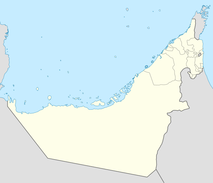
Rikcha:United Arab Emirates location map.svg

Qallariy willañiqi (SVG willañiqi, rimasqakama 1228 × 1056 iñuyuq, willañiqip chhikan kaynin: 152 kB)
| Kay willañiqiqa kay uranpi yapa willasqakunapas Wikimedia Commons sutiyuq chawpi midya hallch'amantam ch'aqtasqa. | Commons nisqapi ch'uyanchana p'anqaman |
Pisichay
| T'iktuna |
Deutsch: Positionskarte der Vereinigten Arabischen Emirate
Quadratische Plattkarte, N-S-Streckung 109 %. Geographische Begrenzung der Karte:
Equirectangular projection, N/S stretching 109 %. Geographic limits of the map:
|
|
| P'unchaw | ||
| Pukyu |
Kikinpa rurasqan, using
|
|
| Ruraq | NordNordWest | |
| Saqillay (Kay willañiqita musuqmanta llamk'achiy) |
Este archivo se encuentra bajo la licencia Creative Commons Reconocimiento-Compartir bajo la misma licencia 3.0 Alemania.
 Este archivo se encuentra bajo la licencia Creative Commons Reconocimiento-Compartir bajo la misma licencia 3.0 Alemania.
|
|
| Huk musuqchasqakuna |
|


|
Este mapa se ha hecho o mejorado en el Kartenwerkstatt (taller cartográfico) alemán. También puede proponer mapas para mejorar.
|
Willañiqip wiñay kawsaynin
P'unchaw/pacha nisqapi ñit'iy chaypacha willañiqi kachkasqata qhawanaykipaq.
| P'unchaw/Pacha | Uchuylla rikchacha | Chhikanyachikuqkuna | Ruraq | Willapuy | |
|---|---|---|---|---|---|
| kunan | 09:19 3 mar 2018 | | 1228 × 1056 (152 kB) | Shahin | Reverted to version as of 14:50, 6 August 2013 (UTC) |
| 09:18 3 mar 2018 |  | 1228 × 1056 (151 kB) | Shahin | 2017 update | |
| 14:50 6 awu 2013 |  | 1228 × 1056 (152 kB) | Chipmunkdavis | Reverted to version as of 09:37, 5 May 2013 Google maps also shows a little bend | |
| 14:45 6 awu 2013 |  | 1228 × 1056 (238 kB) | Chipmunkdavis | Reverting to version with border that matches http://www.emirates.org/the_country.html | |
| 09:37 5 may 2013 |  | 1228 × 1056 (152 kB) | NordNordWest | Reverted to version as of 14:16, 14 August 2012; location maps never get labelled | |
| 07:46 5 may 2013 |  | 1228 × 1056 (212 kB) | Fatemi | Reverted to version as of 07:40, 5 May 2013 | |
| 07:44 5 may 2013 |  | 1228 × 1056 (212 kB) | Fatemi | labled | |
| 07:40 5 may 2013 |  | 1228 × 1056 (212 kB) | Fatemi | new version | |
| 14:16 14 awu 2012 |  | 1228 × 1056 (152 kB) | NordNordWest | c | |
| 20:02 2 nuw 2009 |  | 1228 × 1056 (238 kB) | NordNordWest |
Maypim willañiqita llamk'achinku
Kay rikchamanqa kay qatiq p'anqam t'inkimun:
Mayqin wikikunapi willañiqita llamk'achinku
Kay wakin wikikunam willañiqitaqa llamk'achinku:
- af.wikipedia.org-pi kaykunapi llamk'achinku
- als.wikipedia.org-pi kaykunapi llamk'achinku
- ar.wikipedia.org-pi kaykunapi llamk'achinku
- كأس آسيا 1996
- الدوري الإماراتي للمحترفين
- قالب:خريطة مواقع الإمارات العربية المتحدة
- كأس العالم للأندية 2010
- الدوري الإماراتي 2010–11
- كأس العالم تحت 17 سنة لكرة القدم 2013
- الدوري الإماراتي 2011–12
- كأس آسيا 2019
- بطولة العالم للشباب لكرة القدم 2003
- الدوري الإماراتي 2012–13
- كأس العالم للأندية 2017
- كأس العالم للأندية 2018
- جزيرة زركوه
- جزيرة دينا
- جزيرة قرنين
- جزيرة عش
- جزيرة غاغة
- نهائي كأس العالم للأندية 2018
- كأس العالم للأندية 2021
- الدوري الإماراتي للمحترفين 2021–22
- الدوري الإماراتي 2023–24
- دوري الدرجة الأولى الإماراتي 2015–16
- كأس السوبر السعودي 2023
- ast.wikipedia.org-pi kaykunapi llamk'achinku
- Dubái
- The World
- Burj Al Arab
- Burj Khalifa
- Abu Dhabi
- Guggenheim Abu Dhabi
- Islla de Saadiyat
- Marina 101
- Princess Tower
- 23 Marina
- Centru Dubái
- Islla de Yas
- Circuitu Yas Marina
- Módulu:Mapa de llocalización/datos/Emiratos Árabes Xuníos
- Módulu:Mapa de llocalización/datos/Emiratos Árabes Xuníos/usu
- Aeropuertu Internacional de Dubái
Qhaway mayqin wikikunapim willañiqita llamk'achinku.